La Nina Watch Remains In Effect As Development Odds High For Northern Hemisphere Winter
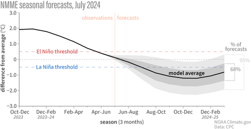
Scientists from the National Oceanic and Atmospheric Administration (NOAA) issued an update Thursday stating that there is a 70% chance La Niña will develop between August and October and a 79% chance between November and January.
#ENSO-neutral is expected to continue for the next several months, with La Niña favored to emerge during August-October (70% chance) and persist into Northern Hemisphere winter 2024-25 (79% chance for November-January). A #LaNina Watch remains in effect. https://t.co/5zlzaZ0D9Z pic.twitter.com/28c2iye7MM
— NWS Climate Prediction Center (@NWSCPC) July 11, 2024
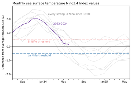
In the first half of the year, waters across the eastern Pacific have rapidly cooled, signaling the end of a strong El Niño. Surface waters across the eastern Pacific have bottomed in recent months. If cooler ocean waters are seen in the months ahead, a stronger La Niña could emerge, producing a more active hurricane season.
The latest reading shows water temperatures in June were just 0.16 °C (0.3 °F) above the long-term average.
NOAA's computer model, including the North American Multi-Model Ensemble, forecasts a "moderate" La Niña later this year.
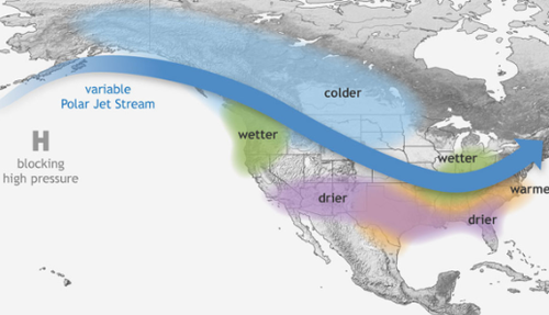
NOAA's historical winter precipitation data forecasts warmer- and drier-than-average conditions across the southern part of the US, colder-than-average conditions across the north-central Plains, and wetter-than-average conditions in the Ohio Valley and Pacific Northwest/northern California.
Government scientist pointed out, "Also keep in mind that there's about a 1-in-5 chance that La Niña won't show up, and neutral conditions will last through the winter."
Let's remind readers that NOAA has previously stated, "El Niño and La Niña are naturally occurring climate patterns and humans have no direct ability to influence their onset, intensity, or duration."
Avoid far-left corporate media outlets that inject climate politics into nearly every weather headline and story they get a hold of to further their radical progressive agenda that's not rooted in reality. Folks are realizing the leftist media is as clueless as Biden.


